


Behind Every Smart Route: The Geocoding Advantage
In the logistics and transportation industry, efficient route planning is crucial. One of the most critical components behind the scenes is geocoding. Businesses increasingly rely on digital infrastructure to streamline operations. To mitigate this, geocoding has emerged as the backbone of every effective multi route planner. This blog explores the role of geocoding in multi route planning software. Its benefits, and how it supports the best multi route planner platforms in delivering optimized logistics performance.
What is Geocoding?
Geocoding is the process of converting textual address data- such as street addresses, postal codes, or place names- into geographic coordinates. These coordinates typically include latitude and longitude. These coordinates allow mapping and routing software to accurately locate addresses on a digital map. Thereby, forming the foundation of any reliable multi route planner.
This conversion is essential for route planning in logistics. It ensures that every delivery or service location is correctly identified. Without accurate geocoding, systems may misplace stops or fail to find them altogether. This leads to missed deliveries, increased fuel usage, and customer dissatisfaction.
Reverse geocoding plays a complementary role by converting geographic coordinates back into readable addresses. This is especially useful for confirming delivery locations, sending customer notifications, and logging completed routes. When combined, these procedures allow for more clever and effective logistics operations.
Why Geocoding Matters in Multi Route Planning
In logistics, time and distance equate to cost. Accurate geocoding ensures that every stop on a delivery route is precisely located, minimizing delays, missed addresses, and fuel consumption.
According to a report by Statista, logistics companies that adopted digital route optimization saw a 15-20% reduction in fuel costs. And also a 20-25% improvement in delivery time. Much of this efficiency comes from reliable geocoding.
Without accurate location data, even the best multi route planner could create inefficient or erroneous routes. Bad data in means bad results out- and in logistics, that translates to dissatisfied customers and lost revenue.
How Geocoding Enhances a Multi Route Planner
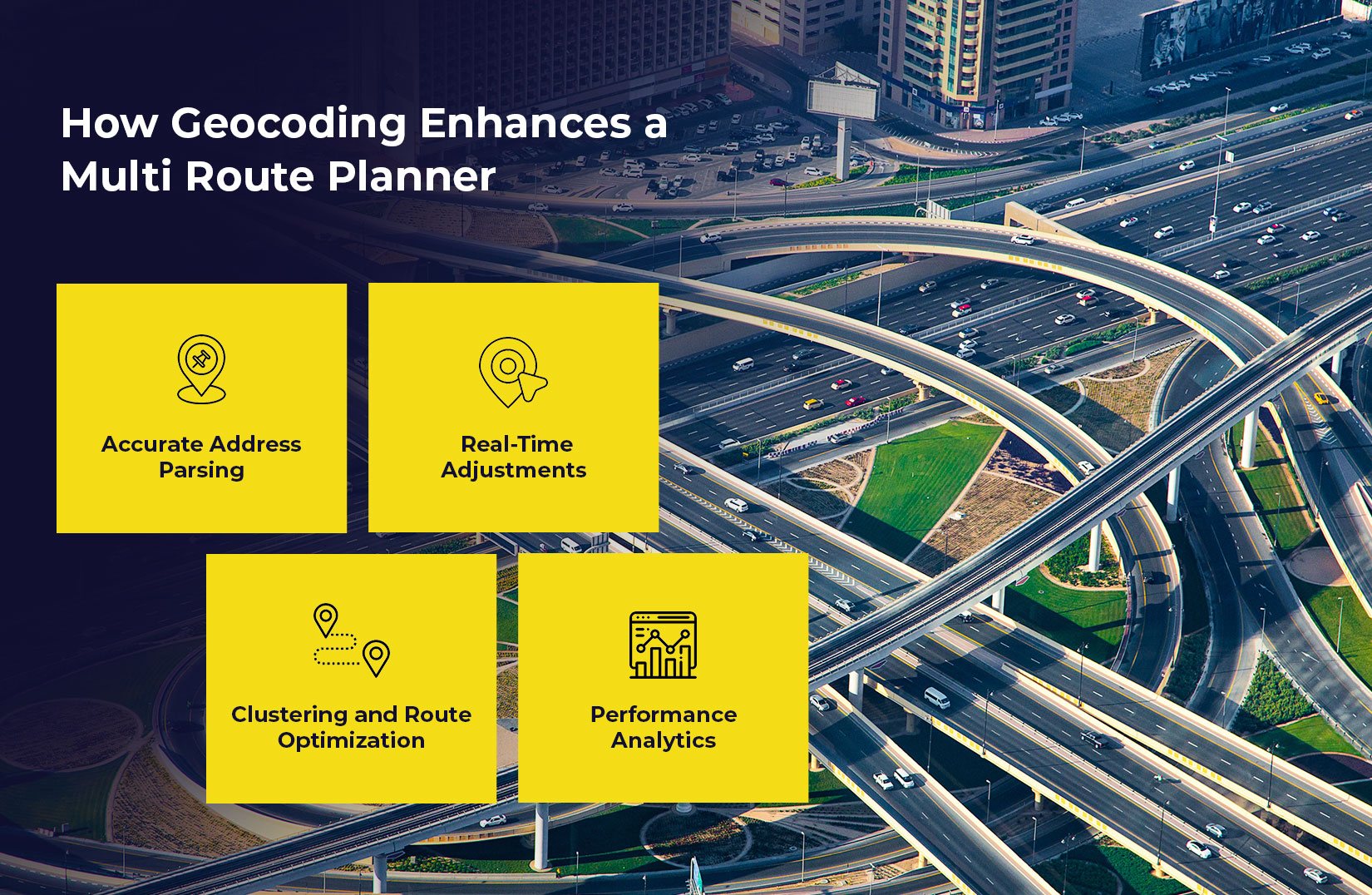
A multi route planner assigns delivery or service tasks to drivers by calculating the most efficient path between multiple stops. Here’s how geocoding supports this process:
1. Accurate Address Parsing:
Geocoding cleans and validates addresses before converting them into coordinates. This reduces errors such as undeliverable addresses or routes that lead drivers to incorrect locations. According to a report by Capgemini, businesses lose up to 13% of their annual revenue due to incorrect address data. This is an issue geocoding helps eliminate.
2. Real-Time Adjustments:
Modern multi route planning software integrates real-time data such as traffic conditions, weather, and road closures. With geocoded data, the system can reroute drivers instantly, ensuring timely deliveries and better resource utilization. Studies show real-time route optimization can cut delivery delays by up to 22%.
3. Clustering and Route Optimization:
Geocoding helps the multi route planning system to group stops based on proximity. Algorithms use this data to design routes that minimize backtracking and idle time. A report by McKinsey found that route clustering through geolocation data can improve delivery efficiency by 15–25%.
4. Performance Analytics:
After deliveries are completed, geocoded data aids in analyzing route efficiency. Managers can identify trends, measure KPIs, and refine strategies for improved performance.
Real-World Use Cases:
Let’s consider a delivery company with 500 daily orders across a major metro area. By integrating a geocoding-enabled multi route planning solution, the company can:
– Reduce average delivery times by 18%
– Lower fuel expenses by 12%
– Increase first-attempt delivery success by 10%
This leads to substantial cost savings and a better customer experience, essential in the competitive logistics landscape.
Choosing the Best Multi Route Planner with Geocoding Capabilities
Not all route planners are created equal. The best multi route planner will offer advanced geocoding features including:
– Bulk address validation
– Support for international formats
– Integration with GPS tracking
– Real-time mapping updates
When evaluating a multi route planning solution, logistics managers should prioritize platforms that emphasize robust geocoding infrastructure. A system lacking this capability will likely suffer from poor route accuracy and reduced operational efficiency.
Geocoding Challenges and How to Overcome Them

Despite its advantages, geocoding can face challenges:
1. Incomplete or Incorrect Address:
Geocoding systems rely on clean and accurate address data. Incomplete or poorly formatted entries can result in failed geocoding or incorrect location mapping. To overcome this, businesses should use systems that offer address suggestion, auto-completion, and validation features during data entry.
2. Poor Rural Planning:
Some remote or less developed areas may not be well-covered by mapping databases. This can lead to inaccurate location identification. To mitigate this, choose a geocoding provider that regularly updates its databases and supports regional address formats.
3. Scalability:
Large logistics operations require the ability to process thousands of addresses quickly. Ensure that your multi route planning software is built to handle high-volume geocoding tasks without delays or performance issues.
Cloud-based platforms often address these issues better than legacy systems, offering more frequent updates and faster processing speeds.
The Future of Geocoding in Logistics
As logistics operations become more data-driven, geocoding will evolve beyond simple address mapping. With the integration of artificial intelligence and machine learning, future systems will predict potential delivery disruptions. Disruptions such as traffic congestion or weather-related delays and adjust routes in real time.
Additionally, geocoding will play a key role in emerging technologies like autonomous vehicles, drones, and smart city infrastructure. These innovations will rely heavily on accurate location data. Which is required to improve routing precision, reduce operational costs, and boost delivery speed and reliability.
Final Thoughts
Geocoding is more than a technical step in address mapping. It’s a strategic enabler that supports the accuracy, speed, and scalability of any multi route planner. For businesses seeking the best multi route planner, prioritizing geocoding functionality is essential.
Whether you’re looking to invest in a multi route planning software for the first time or upgrade your current multi route planning solution, understanding the power of geocoding can guide your decision-making and sharpen your competitive edge. So, book a demo with LogiNext Solutions and get the best multi route planner for your business today. Click on the red button to know more.
95
|
|
|
|


@LogiNext